←portillo argentino | | lo valdés→
Sun 6 Feb: Real de la Cruz–El Caletón (approx 15km, 350m ascent)
The arrieros say that they will load the bikes onto the mules, allowing us to walk unencumbered.
The
Tunuyán crossing | Loading the mules |
Río Palomares | Cos. Palomares |
Co. Marmolejo | Piuquenes ascent |
Piuquenes descent | |
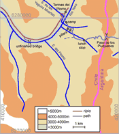
We stopped at the place known to the mulemen as El Caletón, shown by that name on the Tunuyán Andean Club map, and perhaps the same as the Real de la Obeja in their itinerary (or the El Chocolate which is also sometimes mentioned). It is within smelling distance of sulphur springs but we couldn’t be bothered to visit them, preferring to sit in the sun. The Cerros Palomares loom above – strange rock precipices like layers of cardboard. Further on, and visible from the trail, is Co. Marmolejo, a beautiful peak with superb glaciers.
Notes: the journey took us four hours. The terrain is either sandy or rocky all the way, but the route is so short that it would not have been hard to push unladen bikes along it.
El Caletón (3030m) seems to be the last campsite before the Piuquenes. If you have the chance to take photographs of Co. Marmolejo in the afternoon it’s a good idea to do so, since the light is adverse in the morning. We have a page on packing bikes for mules.
Paso de los Piuquenes | |
We make an early start. There is a stream to cross fairly early on, after which the path climbs up reddish slopes. The ground is shaly rather than bouldery. We reach the pass (4030m) in two-and-a-quarter hours without incident. There is more wind than on the Portillo Argentino, and we feel a little cold because we aren’t prepared for it.
At the pass the arrieros unload the mules while we take photos and reassemble the bikes (omitting the pedals because we don’t expect to ride).
The ridge is steep on the west side where we will descend. The path avoids the difficulty by making a large semicircular sweep to the left. There is some snow – still icy – but we can avoid it.
We wave goodbye and set off into the unknown while the arrieros make their return journey. There is no difficulty pushing the bikes on this easier ground, and we make good progress, surrounded by grand mountains.
Near midday we cross a stream at 3400m and stop for lunch. Colin puts his pedals back on, encouraged by the easier ground.
When
 Yeso valley Sketch map |
At 2 pm we reach the Río Yeso (3000m). Holidaymakers are camped on the opposite bank enjoying the Termas del Plomo. But we know that the river will be easier and safer to cross in the morning, so we pitch tent where we are, survey the crossing points, and sit in the sun.
Note: looking back from the valley we reckoned we had taken the best route, though a left turn at the fork corresponds better with the maps.
It would probably not have been all that difficult to push our bikes (unladen) up to the pass; gradient rather than terrain would have been the obstacle.
Tues 8 (dawn): El Yeso crossing
We get up at first light, dismantle the tent, load the bikes, and push them to our appointed crossing point. The river level is satifyingly low. The air temperature is 4, the water 0. Tracey belays while Colin ferries bikes and panniers across (this is the purpose of the rope). Then Colin belays Tracey across.
We push to the Termas del Plomo but they are hidden from the sun and the water is disappointingly tepid. We push round to a sunnier spot and make breakfast.
Note: the route from Manzano to the Termas del Plomo is a magnificent journey. Our general comments and lessons from it are on a separate page. The schedule we eventually adopted – 3 days from Yaretas to the Yeso valley – is the only reasonable one.
GPS readings
place | utm (19H) | alt. (m) | ||
Real de la Cruz | 0435074 6277539 | 2846 | ||
El Caletón | 0423651 6279593 | 3027 | ||
Piuquenes pass | 0418885 6278160 | 4037 | ||
lunch stop | 0417140 6277833 | 3410 | ||
first pillar | 0415950 6278765 | 3167 | ||
Río Yeso camp | 0415476 6279426 | 2996 | ||
crossing | 0415427 6279550 | 2928 | ||
unfinished bridge | 0412496 6277679 | 2840 | ||