| gorges→
Mon: Aït Baha – Tafraoute (97km, 1830m of ascent)
Our hotel minibus took us to Aït Baha, a town with all facilities at 490m above sea level. Most of the drive out was on the flat and busy coastal plain, but there was a pronounced rise before Aït Baha and the hills were beginning to beckon.
We bought some bread and bananas and set off on our bikes. The road is a gentle but remorseless climb for 37km at which point it reaches the first pass at 1260m. We had lunch at a café here. There are a couple of other eating places soon after.
The road descends to 1060m,
Tioulit/Tizrgane |
The second pass is at 1400m, 64km from Aït Baha. The following low is at 1300m and is immediately followed by the climb to the third pass, Tizi n Tarakatine, 1465m and 70km from Aït Baha.
The descent is a new road which
Tizi Mlil | ||||||||||||||||||||||||||||||||||||||||||||||||||||||||||||||||||||||||||||||||||||||||||||||||||
The final 20 km, nearly all downhill, are attractive but cool in the evening air. There is a hotel by the roadside about half way from the pass to Tafraoute. Tafraoute itself is at about 950m, the Amandiers 25m higher.
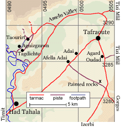 |
The Ameln valley is popular with tourists and particularly with guidebook writers. We rode a few km north of Tafraoute and turned left. The Ameln villages lie to the north of the road, nestling under Djebel el Kest. No doubt they were attractive in their day. But their inhabitants have struck it rich working as grocers throughout Morocco and France, and they spend their money on tartish concrete villas back home to retire to.
We cycled to one of the villages (on piste) hoping that they would connect, but except on foot it seems hard to link them other than by returning to the road.
After a while the new tarmac road to Tanalt to the right was hard to resist. It heads up a brutal gradient (often 1:6) to an obvious col, and as we climbed Colin kept saying to Tracey “I’m sure there’ll be a way down on the other side”. (Colin has no faith in maps which don’t show roads he thinks ought to exist.)
At the col the road veers back and continues climbing, but there is a junction with 2 pistes. One, to the left, follows the ridge; the other, straight on, descends to the valley ahead, but instead of descending further it then turns upwards towards some more villages.
We
Ridge road |
We returned to the junction and took the other piste down to Taourirt. On the southern side of the village two paths make a fork ![]() 0492545 3287607).
0492545 3287607).
Prickly pears |
The lower path isn’t very ridable, at least at our skill level, but it’s short. The village at its end – Agnizgzawn – is pleasant and unspoilt. Here we crossed a stream and joined a piste which took us to the larger track back to the Ameln valley road.
We continued to Had Tahala and returned to Tafraoute along the main road.
To tell the truth this was the least satisfactory day’s cycling.
| gorges→