←yamunotri | | gangotri narrative | kedarnath→
Sun 16 Oct: Netala–Dharali (68km, 1710m ascent)
 |
The ride starts off moderately interesting and a little rolling. Soon we cross a cyclist coming the other way. It’s Bill Weir! We shake hands, and discuss our routes and our plans, and part in our opposite directions.
South of Gangnani the tarmac has been washed away and is hard going. Some of the landslides are recent. We cross to the left bank and climb to Gangnani where we have lunch in one of the many dhabas.
Gangnani dhaba |
Srikanta |
After gaining 200m fairly gently the road now rears up to climb 400m more in steep hairpins to cross a shoulder at Sukhi Top. We drink tea at the summit and plummet 250m to Jhala where we cross again to the true left bank. There is an increasing feeling of being in the mountains. But the road returns to good behaviour, rolling benignly along the floor of a U-shaped valley. We pass the turnoff for Harsil, and soon reach our destination for the night, the Springdale hotel near Dharali.
Notes: Bill is an American guidebook author and cycle tourist. We had heard on the Internet that he was going to Garhwal and had been in touch with him. Having arrived in India before us he kindly sent us some information before our departure.
He had stayed at the Springdale himself, and it was quite pleasant.
Mon 17: Dharali–Gangotri (21km, 600m)
We woke up to a crisp clear morning. We had clear views, and saw for the first time a beautiful mountain to the south which had been hidden by yesterday afternoon’s cloud: perhaps the 6133m Srikanta.
It’s
Bhagirathi Valley | Gangotri | |
Higher up the valley one of the peaks of the Hanuman Tibba group stands out like a thin angled flake.
Gangotri is a small town serving pilgrims and travellers, mostly laid out along its main alley. We stayed in a hotel near the temple commanding fine views up the valley.
During the afternoon we arranged a porter, Ramesh, through the hotel for the following day.
Trail | Manda |
Autumn foliage | Bhagirathi |
We left our bikes at the hotel for the popular short trek to Gaumukh, the snout of the Gangotri glacier which feeds the Bhagirathi river. Ramesh carried our luggage in three panniers.
The trail is well made with regular tea stalls. Ever finer mountain views lure the walker on. The vegetation is a delight, with deciduous trees and bushes turning many colours. After 9km Chirbasa provides a resting point. The sheer-faced Manda peaks dominate the view to the south.
Bhojbasa is reached after a further 5 km, with superb views of the three Bhagirathi peaks up the valley. There are tea stalls, an ashram, a GMVN resthouse, and a meteorological station.
Notes: The resthouse has been devastated by avalanches and offers only dormitory accommodation. Bhojbasa is a cold place, hard to endure without a sleeping bag.
Weds 19: Bhojbasa–Gaumukh–Gangotri (24km, 270m)
Shivling
Shivling |
Notes: Gaumukh itself is over-rated; worth going to see but not really worth seeing. It is possible to proceed further to Tapovan, although this entails a glacier crossing. The slope above Gaumukh is prone to stonefall, and Ramesh advised us to keep to the stream side of the moraine.
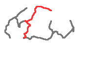
Thurs 20: Gangotri–Uttarkashi (95km, 635m)
A straightforward ride. We reached our hotel at about 4pm.
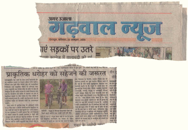 Notes: in fact we stopped a couple of km short of Uttarkashi at the Monal Tourist Home, whose signboard we’d seen when coming the other way. It’s unusually comfortable and friendly, and modestly priced. The proprietor speaks good English and is a source of advice. He has cycled to Gangotri himself. He arranged for us to be interviewed by the local paper. Once or twice later we met people who’d seen the interview and commented on it.
Fri 21: Uttarkashi–Chamba (105km, 1975m plus a ride in a pickup)
We had a scheme for avoiding the main road south. A minor road climbs up to the Chaurangi Khal to the west and then descends to Bhaldiana Bend not far from Old Tehri. We had reservations about this route, and indeed the whole Tehri area. It had been blighted for years by a dam project and lacked tourist facilities; such few as it had had were now being submerged. But we were assured that we would manage.
It
Descent |
Now the road started to play tricks on us. The main road we were aiming for was high above us, and when we reached it it climbed further over a shoulder – about 330m climbing in all. Then it began descending only to revert to more climbing. Night fell and we fixed lights just before reaching Dobata Bye Pass, a honking mass of trucks and buses. We could see no option except to pursue the road upwards, hoping to find somewhere to stay. By the time we’d climbed another 270m we reached the small village of Jakh and were becoming desperate. We asked advice in a small shop. It was a long way uphill to the nearest hotel at Chamba, but a neighbour was willing to take us there in his pickup for 500 Rs. We didn’t hesitate.
Notes: Chamba is a sizeable place with several hotels. Bill Weir had had an easier time: riding south from Gangnani he’d stayed on the main road and broken his journey at Dobruta, from where he’d been able to reach Ghansyali the next day. There is a PWD resthouse at the Chaurangi Khal, and if we’d known better we might have tried to stay there.
Our difficulties had been made worse by a late getaway in the morning. Breakfast wasn’t served until 8 o’clock, and it wasn’t easy to find the right road to the Chaurangi Khal. The route crosses the bridge into Uttarkashi and turns immediately left. When the road peters out at a junction at the edge of town you turn left again; the right turn here is signposted for the Nehru Institute of Mountaineering. Ask directions whenever you’re in doubt.