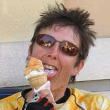
| photos
We made a 6-day tour of the Gennargentu mountains, then spent a week in a holiday house near Dorgali and found some mountain bike rides near there.
| 
| 
| 
| 
|
Maps. Sardinia is not all that well mapped. The main tarred roads are recorded well enough and for the most part they are wide 2-lane roads, unlike in Corsica. Gravel tracks, mule tracks and paths are very unreliably mapped. We had a very old Lying Club of Italy map which was a fat lot of use really. Ivan lent us his Reise-Know-How 1:200k which wasn’t bad for roads, mostly. Ivan says it is not to be trusted for footpaths. We found a couple of Edizioni Abies 1:30k walking maps from the Internet, and a map-like object claiming to describe a mountain bike route T-track based on old transhumance tracks. We knew of the existence of a mountain bike guide but as it was called South and East we thought it didn’t cover where we were going. In fact it does have rides, and would have been very useful. The book is Mountain Bike in Sardegna, there’s an english as well as Italian version (one of the authors is English), published by Versante Sud.
Transport. Sardinia is better provided with transport than with maps. Usefully for us there’s a Bristol-Olbia EasyJet flight once a week. Olbia airport is new, small, and pleasant. The island’s main public bus company, ARST, runs buses from the airport to the centre and there are large buses into the mountains. They take their time but they carry bikes and are efficient. From the centre of Olbia you pick up the bus from the stop near the level crossing - not from the bus depot nor the old bus station which is derelict.
Hotels. Although the mountains are wild and sparsely populated, there are sufficient hotels a day’s ride apart, and there are some very good ones. Restaurants convenient for lunch were less frequent.
Tour
Nuoro - Su Gologone.
Not far, mostly downhill and with a tailwind; in short, a skive. Su Gologone is excellent, has a pool, and a huge antipasti buffet.
Su Gologone - Aritzo
nice old ladies |
Fonni’s finest |
It is somewhat uphill to Oliena but there is a divertingly spectacular line of cliffs south of the road. Oliena is pleasant even if the old ladies are armed to the teeth. A long climb continues to Orgosolo, which from this approach has a decidedly grim aspect of half-built concrete blocks glowering from atop a ridge. It has the reputation as the bandit capital of the island but happily the bandits have taken up painting these days. It contained some roadworks. Orgosolo, rather like Oliena, is a maze of twisty little passages, all alike. Then a fairly rolling, long climb to Pratobello, through a mixture of woods then part wood and part cleared grazing land, then to Fonni through grazing land reminiscent of the Welsh borders. I think we had expected Sardinia to be drier, scrubby and more like Malta I suppose. The greenery and all the sheep were a surprise. More startling were aparent large patches of snow on the hills in the distance.
The guidebook lists three hotel-restaurants in Fonni none of which was open but there was a chip van instead. Annoyingly we found a restaurant just out of town as we rode out, but the chips had been pretty good. We had done about half the climbing; the rest of it evolved itself very slowly over the course of the afternoon. I don’t know how it got done but we were too tired to notice. The Fonni-Desulo road went through dense mixed forest. Just before the summit Fascussi we stopped at the petrol-station cafe in desperation for cake, not that they had much but they did have a newspaper which confirmed Cav’s victory on the final Giro stage. Again much to our annoyance there was a much more convincing cafe-reaturant near the top of the pass.
We had hoped to take a minor road along the ridge to just the other side of Aritzo, but a sign said the road was closed at 8km. I strongly suspect we could have got through, but the possibility of a long extension to the ride at this stage deterred us, and a car-driver indicated we had to go the other way. So a long descent through Desulo and down to the valley and a long drag up which we did in our sleep.
Aritzo - Seulo
|
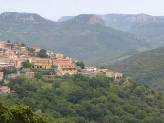
Gadoni and typical landscape |
stiddiosa |
The main road climbed a little then descended through Gadoni. Landscape of rugged cliffs. At the Flumendoso valley this wide new road crosses on an ugly concrete viaduct; we found the old road still existed and got some extra roughstuff and extra climbing. Road climbs slowly round a broad hillside to a summit where the Miramonte hotel is.
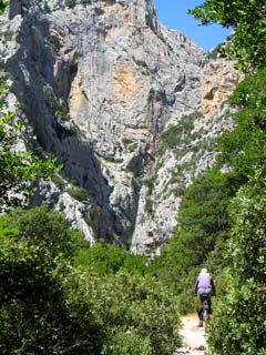
gravel road up Perdedu |
|
view from the summit |
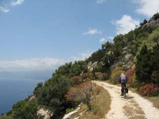
The other side, climbing north from the hotel is a footpath sign to M. Perdedu. In fact it’s a road almost all the way, singletrack, mostly paved, later stone and cobbles, and a wonderful high wild ride with expansive views down to the Flumendosa valley and far away to the striking rocks of Perde Liana.
Seulo - Villagrande Strisaili
The minor road passes the Alto Flumendosa reservoir and winds up at the main road. We rode into Villanova before digging out the paperwork which told us the hotel was near Villagrande. Roll eyes at Colin, etc.
Villagrande - Su Gologone
The forecast wasn’t too good. We set off in dryish weather. We tried to find a roughstuff alternative to Villanova, marked on the T-track map. We did find a stone-built track in some woods with some sort of incomprehensible map on a signpost at the start but it didn’t seem to be heading in quite the right direction and it was a little bumpy with cobbles. We disputed whether this was fun or not but agreed on giving up. From Villanova we had the choice of the old main road or something more to the west side, along the lake for a while. The latter was quiet, narrow, and completely deserted. It came with a beautiful new surface which led the way up a short rise only to be replaced what was less a road than a series of potholes laced together with the remains of some tar. We descended into a rather woebegotten area with scrappy farm buildings - to be fair, the the weather wasn’t helping - and climbed effortfully towards the main road high above. The track had a few junctions here but it looked mainly intent on heading away from the new road. This felt wrong but it was ok and later we were rewarded with some new tarmac again. It was quite a nice road really with a curvy descent to the main road.
The temperature was 8 degrees. It was exactly like Wales. The sky was Welsh - not totally uniformly rainfilled but held a bit of hope. The wild green rocky mountainscape, with sheep, looked exactly like the Nant Gwynant climb only bigger. We could see a building ahead at the pass. Colin had thoughts of cafes. Since the main road went 200 vertical metres below and through a tunnel I thought a cafe was unlikely. Indeed the building was a forlorn shell. I thought of photographing it but was too cold.
The scenery was tamer the other side, a gentler slope down of forest and scrub. The rain eased. At the valley floor the old road heads straightish and runs past a fine Nuraghic tomb, incorporating a convenient bench for lunch. Then a gentle up and down to Orgosolo, where a tour-group of comfotabley middle class German Angela Merkel voters was being shown the anticapitalist protest murals. In Oliena we found a cafe with a couple of cakes. Then easy back to Su Gologone where in the sunny gaps between the clouds we got into the pool.
Dorgali
Now for the holiday part of the holiday. We met Edouardo, the house owner in town. Usefully Edouardo has a large pickup because the house is 7km from town. There is a 270m altitude difference between the house and the town. The afternoon’s expedition was to the shops. Edouardo has a lot of books which put up a good fight against our cycycling plans for the week.
 |
 |
By an amazing coincidence Colin reached the road just where 2 Austrian women on bikes were stopped and trying to figure out from a bad sketchmap where they were. we didn’t recommend our down route as a ride up. The route back to Cala Gonone was paved.
It wasn’t quite lunchtime. Colin I gathered must have planned on lunch nowish because he had manged to delay things by riding over a thorn yesterday whose slow puncture just became as we rolled into Cala Gonone. He had not anticipated the speed I can fix punctures. I insisted we do the track north of CG before lunch. Actually this wasn’t hard and only took an hour or so and is very nice. The shubbery on the coast side was a little different from inland. Here there was more an element of different shades of leaves and all the shrubs developed in rather pleasing even round shapes. The Cormoran restaurant does a very nice courgette, bottarga and prawn pizza.
We rode back to Dorgali over a road to the north which was a concrete mountain which climbed and climbed some more and was very annoying.
Another ride we tried was one marked on the Abies map. From the main road, a left turn up over a pass then southwards to Parco del Cervo. The turn was almost invisible if you aren’t looking for it and the ridge above looks impossible to cross. We rode about 1ft before resorting to pushing. It was rocky and loose. But at least not hard to follow. After the top it splits into a million obscure ways. We headed what we reckoned was southwards through woods woo actually rideable to some enclosures and sheds containing fircely barking dogs. There was a derelict pickup and it felt slightly unwelcoming. There was no obvious way through - we backtracked a different way and picked up a way going possibly northwards which seemed right, indeed it descended to a sort of junction where this way way marked with a cairn.
From here it was fairly clear. The path was intermittently rideable, some of it quite nice. It felt very remote and lovely. Again mostly in woods. We even saw a route mark painted. After a lot of pushing we came to a junction which guessing from distance covered and altutude was where the map marks the path becoming a track (the track continues down the valley). The track was no easier despite being a track because it was steep. Near the top of the pass, wheere the map marks us joining a slightly bigger track, the slightly bigger track heading further south looked completely overgrown. We’d been planning to take this to continue past the Nuraghic village but we’d had enough by then and went home for lunch.
On the last day the flight back was late in the day. The Deplano bus company had just started up a service leaving Cala Gonone getting to the airport at just the right time (it takes 3 hours, but it’s a bus). We sat on the beach. We had pizzas and ice cream.
Footnote: soon after our return, we lost the originals of most of our photographs owing to a burglary. The low-res images on this page are the best we can do.
| photos